
About:
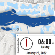
The devastating 2019 and 2011 Missouri River floods have had severe and lasting impacts on western Iowa communities. The increasing frequency of major Missouri River floods and their associated damages highlight a need for a Missouri River flood modeling system capable of estimating flood impacts based upon historical, forecasted, and hypothetical flow scenarios. Having such a system will allow agencies, communities, and individuals to make informed decisions during the evolution of future flood threats and improve management of the Missouri River floodplain. With funding from the U.S. Department of Commerce Economic Development Administration, the Iowa Flood Center participated in the Comprehensive Assessment and Resiliency Plan for Mills and Fremont Counties to create the Missouri River Flood Information System (MRFIS). The system builds upon the award-winning Iowa Flood Information System (IFIS) that provides real-time flood alerts and forecasts, river levels, weather conditions, and more for the entire state of Iowa. MRFIS provides comprehensive information on floods, streamflow and mitigation scenarios, and levee systems that can be easily modified to represent breaches.
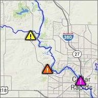
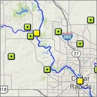
Besides IFIS core features, system provides a variety of mitigation and flood scenarios:
2011 Flood Event
Simulation uses flow observations at stream gaging stations during the 2011 Flood.
2019 flood event
Simulation uses flow observations at stream gaging stations during the 2019 Flood.
2011 flood event without levee breaches
Simulation without observed levee breaches. Levees were allowed to overtop during the simulation.
2019 flood event without levee breaches
Simulation without observed levee breaches. Levees were allowed to overtop during the simulation.
2011 event with new levee alignment
Simulation uses inflows as the 2011 Flood, but includes the base future conditions levee geometry. Levees were not allowed to breach but could overtop during the simulation.
2019 event with new levee alignment
Simulation uses the same inflows as the 2019 Flood, but includes the base future conditions levee geometry. Levees were not allowed to breach but could overtop during the simulation.
Transposition of April 2016 storm event to SW Iowa
Storm transposed from northwest to southwest Iowa that occurred during late April 2016.
Transposition of March 2019 precipitation to SW Iowa
Simulation includes the heaviest swaths of the March 2019 precipitation transposed from central Nebraska to southwest Iowa. Pre-European settlement
Simulation uses the April 2016 storm transposition modified to represent pre-European settlement conditions.
Improved soil
Simulation uses the April 2016 storm transposition modified to represent improved soil health conditions.
The devastating 2019 and 2011 Missouri River floods have had severe and lasting impacts on western Iowa communities. The increasing frequency of major Missouri River floods and their associated damages highlight a need for a Missouri River flood modeling system capable of estimating flood impacts based upon historical, forecasted, and hypothetical flow scenarios. Having such a system will allow agencies, communities, and individuals to make informed decisions during the evolution of future flood threats and improve management of the Missouri River floodplain. With funding from the U.S. Department of Commerce Economic Development Administration, the Iowa Flood Center participated in the Comprehensive Assessment and Resiliency Plan for Mills and Fremont Counties to create the Missouri River Flood Information System (MRFIS). The system builds upon the award-winning Iowa Flood Information System (IFIS) that provides real-time flood alerts and forecasts, river levels, weather conditions, and more for the entire state of Iowa. MRFIS provides comprehensive information on floods, streamflow and mitigation scenarios, and levee systems that can be easily modified to represent breaches.
Besides IFIS core features, system provides a variety of mitigation and flood scenarios:
2011 Flood Event
Simulation uses flow observations at stream gaging stations during the 2011 Flood.
2019 flood event
Simulation uses flow observations at stream gaging stations during the 2019 Flood.
2011 flood event without levee breaches
Simulation without observed levee breaches. Levees were allowed to overtop during the simulation.
2019 flood event without levee breaches
Simulation without observed levee breaches. Levees were allowed to overtop during the simulation.
2011 event with new levee alignment
Simulation uses inflows as the 2011 Flood, but includes the base future conditions levee geometry. Levees were not allowed to breach but could overtop during the simulation.
2019 event with new levee alignment
Simulation uses the same inflows as the 2019 Flood, but includes the base future conditions levee geometry. Levees were not allowed to breach but could overtop during the simulation.
Transposition of April 2016 storm event to SW Iowa
Storm transposed from northwest to southwest Iowa that occurred during late April 2016.
Transposition of March 2019 precipitation to SW Iowa
Simulation includes the heaviest swaths of the March 2019 precipitation transposed from central Nebraska to southwest Iowa. Pre-European settlement
Simulation uses the April 2016 storm transposition modified to represent pre-European settlement conditions.
Improved soil
Simulation uses the April 2016 storm transposition modified to represent improved soil health conditions.